Kings Park and Bold Park maps
As public parks, Kings Park and Bold Park are free and open for visiting 24 hours a day, every day of the year. Whether you are looking for attractions and activities, planning transport options, or researching an event or function, we have the maps to guide your visit.
Kings Park Maps
Kings Park - visitor map
Come and visit us! With attractions, cafes, events, venues and memorials, there is so much to see and do in Kings Park.
Download the Kings Park visitor map
WA Botanic Garden - visitor map
The beds of the Western Australian Botanic Garden are grouped by regions of the State, various taxonomic groups and some purely for spectacular display. The regions include the Wheatbelt, Goldfields, Stirling Ranges, Rottnest and Garden islands, the Kimberley, Mulga, Southern Coastal and Darling Range, with other beds dedicated to key endemic genera such as Verticordia, Boronia, Grevillea and Hakea, waxes and kangaroo paws and Eucalyptus.
Download the Western Australian Botanic Garden Map
WA Botanic Garden - venues map
The Western Australian Botanic Garden showcases over 3,000 varieties of the State's unique flora, including many rare and threatened species. The magnificent landscaped gardens and parkland lawns are a favourite for weddings, picnics, and attending outdoor live music and theatre. A number of hire venues are available.
Download the WA Botanic Garden Venues Map
Fraser Avenue Precinct map
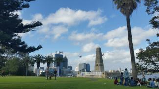
Fraser Avenue leads the visitor from Kings Park Road, West Perth into the major tourist and restaurant precinct. A short walk takes visitors to the State War Memorial and Western Australian Botanic Garden entrance.
Download the Fraser Avenue Precinct Map
Rio Tinto Naturescape Kings Park map
Rio Tinto Naturescape Kings Park is a place for children to connect with nature and learn to appreciate the unique Western Australian environment. It is a place to explore, climb rocks and ropes, wade through creeks, build cubbies and get dirty. There are many great reasons to visit and things to do but please note that it is not a playground or picnic area. It has been designed to retain as much of its natural bush setting as possible.
The main entrance is located along May Drive in Kings Park, readily accessible via Fraser Avenue, Saw Avenue or Poole Avenue, Kings Park.
Download the Rio Tinto Naturescape Kings Park map
Saw Avenue Picnic Area map
Saw Avenue Picnic Area is a quiet corner of the park, perfect for family picnics and barbecues.
The Kulbardi Pavilion (formerly Variety Pavilion) remains a popular hire venue in this precinct, along with a number of hire venues available for group bookings.
Download the Saw Avenue Picnic Area Map
May Drive Parkland map
The May Drive Parkland is a recreation area for the entire family, on the western side of Kings Park and easily accessed via Saw Avenue or Poole Avenue. The playground is particularly suitable for children over six years with a 75-m long elevated walkway, island fort, large-scale replicas of extinct Australian mega fauna and an interactive water misting forest.
Zamia Cafe offers wonderful food, coffee and service in a unique setting in the May Drive Parkland, surrounded by the Backyard Botanicals demonstration garden. The Bovell Kiosk is also on site and opens during busy times for visitor convenience.
Manicured lawns and free electric barbecues make it an ideal picnic venue and evening outdoor cinema provides a popular attraction during summer. A number of hire venues are available for group bookings.
Download the May Drive Parkland map.
Poolgarla Family Area map
The Poolgarla Family Area is accessible via Kings Park Road on the Park's northern boundary and is most suited as a family and recreation space. The Ivey Watson Playground provides an ideal play area for children under six years. Koorak Cafe and Poolgarla Parkland (formerly Hale Oval) provide ideal facilities for families, with older children enjoying ball sports, the popular space net and the 'learn-to-ride' bicycle path.
Download the Poolgarla Family Area map.
Kings Park Education map
Action-packed education programs for students from kindergarten to tertiary are presented by Kings Park Education. All programs are linked to the Australian curriculum and delivered by qualified educators. Spectacular outdoor learning spaces and the sustainably designed Kings Park Education Centre provide excellent locations for all programs.
School groups: Whether you are visiting Kings Park and Botanic Garden for a picnic, a play or an education program, please let the Education Bookings Officer know you are coming. This will ensure your enjoyment and safety in case of an emergency.
Download the Kings Park Education Map
Kings Park - picnic and BBQ areas map
Kings Park and Botanic Garden is a beautiful setting for a family picnic or barbecue, with many ideal locations found throughout the parklands. If you wish to secure a venue for your event, booking fees are applicable. Venue bookings do not include exclusive use of the free electric barbecues which are available on a first come, first served basis. The Bookings Section provides further details on how to book a function.
Download the Picnic and BBQ Areas Map
Kings Park - cycling paths map
Cycling is a great way to get around and see Kings Park. Cycling is permitted on all roads in Kings Park, but restricted to designated pedestrian / cycle paths only. Cyclists must abide by the WA Road Traffic Code 2000 and adhere to Botanic Gardens and Parks Authority Regulations, signs and directions – Penalties apply.
Automated cycle hire is available in the Wadjuk Carpark and bike racks are located throughout Kings Park. Secure your bicycle with an anti-theft lock and take your valuables with you.
Cycling is not permitted in the following areas:
- throughout the WA Botanic Garden
- the Fraser Avenue Precinct around Aspects of Kings Park Gallery Shop and State War Memorial area
- May Drive Parkland
- Saw Avenue Picnic Area
- Ivey Watson Playground, Poolgarla Family Area.
Download the Cycling Paths Map
Kings Park Bushland - tracks and cycle paths
Two thirds of Kings Park is protected as managed bushland and provides an important haven for visitors and native biodiversity.
There are a series of walking tracks and designated pedestrian/cycle paths through the Kings Park bushland that allow visitors the chance to appreciate Kings Park's unique flora, fauna and fungi.
For those seeking an interpretive walking experience, we recommend the Bushland Nature Trail which offers unique encounters with WA's biodiversity or the longer Law Walk which provides stunning river views and an insight into the Mount Eliza escarpment.
Download the Kings Park Bushland Map
Kings Park - fitness training map
The Authority welcomes those wishing to participate in healthy activities and has a number of ovals and grassed areas suitable for fitness groups within Kings Park and Botanic Garden.
All commercial fitness activities require written permission from the Authority and must comply with the Terms and Conditions and Botanic Gardens and Parks Regulations 1999. Please ensure you are aware of the requirements for Fitness Training.
Download the Kings Park Fitness Training Map
Kings Park - memorials and statues map
Kings Park and Botanic Garden has more memorials and statues than any other park in Australia.
Download the Kings Park Memorials and Statues Map
Bold Park Maps
Bold Park - visitor map
Bold Park has an impressive biodiversity of native flora, fauna and fungi. The network of walking trails provides the perfect environment for enjoying a quiet stroll, guided walk, nature study or a challenging workout with specific tracks suited to varying levels of fitness.
Download the Bold Park Visitor Map